ATTENTION: The software behind KU ScholarWorks is being upgraded to a new version. Starting July 15th, users will not be able to log in to the system, add items, nor make any changes until the new version is in place at the end of July. Searching for articles and opening files will continue to work while the system is being updated.
If you have any questions, please contact Marianne Reed at mreed@ku.edu .
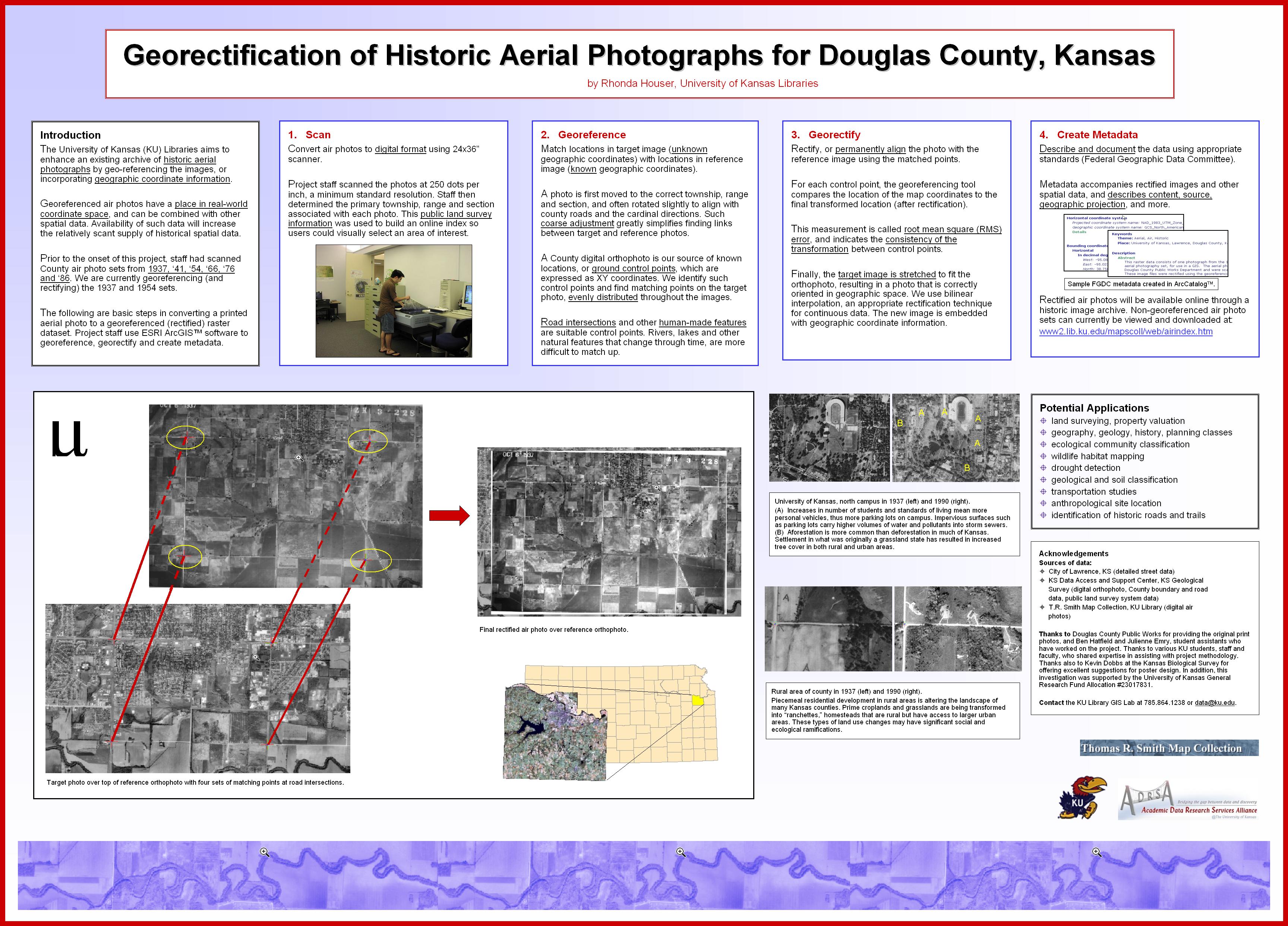
Georectification of Historic Aerial Photographs for Douglas County, Kansas (POSTER)
| dc.contributor.author | Houser, Rhonda | |
| dc.date.accessioned | 2004-12-22 | |
| dc.date.available | 2004-12-22 | |
| dc.date.issued | 2004 | |
| dc.identifier.citation | http://maplibrary.esri.com/LibraryService/DownloadedFiles/esri_poster.jpg | |
| dc.identifier.uri | http://hdl.handle.net/1808/188 | |
| dc.description.abstract | This poster describes a project to georeference and georectify historic aerial photographs for Douglas County in northeastern Kansas. The University of Kansas Libraries wanted to enhance an air photo archive and allow integration with other spatial data. Georectified photos represent a unique and widely germane resource for the historic county landscape. Additionally, the project adds to the relatively scant supply of historic spatial data, especially that in raster format. ArcGIS was used to georectify and create metadata for the images. Staff attempted to identify evenly distributed control points, and to choose an adequate number of control points while minimizing error. Points were more difficult to identify in rural areas where land was fairly homogeneous and alterations such as dam construction had occurred. Images covering towns and cities were easier to process, especially where landmarks were present. This project begs such questions as ‘How has the land changed and why?’ | |
| dc.description.sponsorship | University of Kansas General Research Fund Allocation #23017831 | |
| dc.format.extent | 1202810 bytes | |
| dc.format.mimetype | image/jpeg | |
| dc.language.iso | en | |
| dc.publisher | Environmental Systems Research Institute Map Library (online) | |
| dc.subject | Georeference | |
| dc.subject | Georectification | |
| dc.subject | Historic | |
| dc.subject | Photographs | |
| dc.subject | Raster | |
| dc.subject | Aerial | |
| dc.title | Georectification of Historic Aerial Photographs for Douglas County, Kansas (POSTER) | |
| dc.type | Other | |
| dc.rights.accessrights | openAccess |